Having spent nearly ten days over the Arabian Sea, Cyclone Biparjoy is one of the longest-lasting cyclones to impact India in recent decades. The longer a cyclonic storm hovers over the sea, the more moisture it accumulates — increasing the chances of destructive storms after it makes landfall.
The moment weather forecasters first detected Biparjoy brewing as a meagre Low Pressure Area in the Arabian Sea, they could tell that this would-be cyclone could pack a punch. What they never would've guessed was just how fast the cyclogenesis would be.
Biparjoy's journey from a cyclonic circulation (June 5) to a Very Severe Cyclonic Storm (June 7) spanned a mere 48 hours, making its intensification faster than May's Cyclone Mocha. But Biparjoy didn't stop there and further developed into an Extreme Severe Cyclonic Storm over the weekend.
While an exceptionally warm Arabian Sea and a weak monsoon onset played a significant role in Biparjoy's rapid intensification, favourable Madden-Julian Oscillation conditions in the Indian Ocean and Equatorial Rossby Waves in the Arabian Sea further fanned the flames of cyclogenesis.
However, even as various weather models predicted Biparjoy's evolution into an Extremely Severe Cyclonic Storm, there seemed to be some clash with respect to its movement.
NOAA's GFS (Global Forecast System) initially indicated that Biparjoy was heading towards Oman, while the ECMWF (European Centre for Medium Range Weather Forecasting) hinted that it was moving towards Pakistan and the adjoining north Gujarat coasts. But the India Meteorological Department's GFS suggested it was approaching the Iran-Pakistan coasts.
Defying these forecasts, Biparjoy ended up recurving and is now predicted to move slightly east towards the northern Gujarat coast instead of Pakistan's coastline.
According to the IMD, the Extremely Severe Cyclonic Storm Biparjoy over the east-central Arabian Sea had moved northwards overnight and lay centred over the east-central and adjoining northeast Arabian Sea as of 5:30 AM today.
More precisely, it was stationed about 340 km southwest of Gujarat's Porbandar district and 640 km south of Karachi in Pakistan. It reached peak intensity today, with wind speeds touching 165-175 kmph, gusting to 195 kmph.
But it is likely to gradually deintensify into a Very Severe Cyclonic Storm once again by this evening and might sustain a wind speed of 155-165 kmph, gusting to 185 kmph.
Weather models indicate that Biparjoy will continue its northward voyage until Wednesday (June 14) before moving north-northeastwards, crossing Saurashtra-Kutch and adjoining Pakistan coasts. It will touchdown between Mandvi (Gujarat) and Karachi (Pakistan) near the Jakhau Port (Gujarat) Thursday noon (June 15) as a very severe cyclonic storm with a maximum sustained wind speed of 125-135 kmph gusting to 150 kmph.
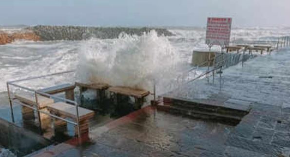
Under the cyclone’s influence, heavy rains (64.5 mm - 115.5 mm) have been forecast over Saurashtra and Kutch over the next few days. And once Biparjoy makes landfall in Gujarat, it is likely to result in 2-3 metre storm surges, destruction of thatched houses, damage to pucca houses and roads, floodings, widespread damage to standing crops, plantations and orchards, and disruption of railways, powerlines and signalling systems in the northern and western coastal districts of Gujarat, as per the Regional Specialised Meteorological Centre (RSMC).
(With inputs from agencies)